Wednesday, May 1, 2013

Dionysus and My Island- NAXOS

Apparently I am not the only one who loves Naxos- over the course of history this island has been home to many, many civilizations- some of which, I am sure, are yet to be discovered. I will try and give you just a brief overview of its known history to give you a sense of the place...

 Legend has it that Zeus was reared in a Naxian mountain cave called Mount Zas . It was there that the mystical eagle gave Zeus the gift of thunder which he used to become the ruler of Olympus- home of the gods. The island was also where Dionysus, the god of wine, was born  (his cult supposedly still
exists on the island). The island's Cycladic civilization dates back to 3000 BC but archeologists are uncovering older settlements all of the time. The Mycenaeans were there from about 1600-1200BC and the Ionians got rich developing the sea trade in 700 BC. The Macedonians, Romans, Egyptians and Rhodesians ruled in some form of succession until 1204 when a Venetian named Marco Sanudo took over the island and build a huge medieval castle in what is now the center of the Chora (which means "the Main City"- all Greek Islands have a "Chora"). The Sanudos rule lasted until 1566 when the Turk, Barbarossa conquered and plundered the island. The Turks were briefly interrupted by the Russians and finally in 1821, through a war of independence, Naxos was united with the rest of Greece. Pshewww....

The Island is large, covering 166 square miles with it's imposing Mount Zas reaching up 3000 feet. It has good fresh water sources that allows the land to be fertile which is unusual for an island in the Cyclades. It is self sufficient and the food that is grown there is delicious. Amazing, perfect, and sometimes uninhabited beaches run all along it's western shore. It's quaint, charming towns have barely changed since antiquity. Donkeys still carry goods from one village to the next, many roads are still sandy tracts, and for the most part the weather is mild and the sea is blue and calm.

We meet good friends from around the globe here every September. The friends all congregate around my cousin, David, who left England years ago and became a barmen and night club manager on the Island. He knows everything there is to know about the place and makes the most fantastic tour guide. While everyone is not lucky enough to have a David, it will help to know that September is the perfect time to go. The summers are hot and crowded with tourists, but September brings milder temperatures and the families have all gone home. Mind you, there are still plenty of folks around, the restaurants will be full but you can  get a seat and the beaches close to town still have plenty of sunbathers on them but you will be able to find a secluded cove made just for you.

It is HARD to get to Naxos- that is why is has remained so untouched. One of the best ways to get there is by ferry. I think that the Greeks have an amazing ferry system. This sentiment is not held by everyone but it has always worked for us. We board the the ferry in Piraeus which is a port in southern Athens. This gives us time to stay a couple of nights in the Plaka ( the Old Town of Athens -which is magical in its own right and deserves more that a quick mention here) where we dine in the shadow of the Acropolis and stroll around the ancient streets haunted by the likes of Aristotle and Plato. From the Plaka you can get to Piraeus by train (subway) in about an hour. You will want to take the "fast" ferry to Naxos which takes 5 hours- but before you gasp- you will be cutting across the bright blue Aegean Sea in a state of the art hydrofoil equipped with restaurants, bars, cushy seats and even private cabins if you so desire- it's pretty fantastic!

Arriving in Naxos is amazing. The chora is a port with a lovely sea front brimming with tavernas and restaurants . Just off the shore there is an islet that houses the iconic skeletal remains of the Temple of Apollo known as the Portara. Built in the 6th century BC the huge gate is comprised of 3 Naxian marble blocks each weighing 20 tons and faces the island of Delos. In fact Naxos is famous for its marble quarry and many of antiquities masterpieces were carved from her stone.

 A "parallia" runs the length of the waterfront. The parallia is a wide plaza filled with outdoor restaurants on the water side and shops on the city side. Sailboats and small fishing craft bob up and down in the small public marina. Above the parallia is the old town which is a labyrinth of tiny, cut stone alley ways leading up to and through  the venetian castle. The roads were built like this to confuse
pirates- once they got in they would find it hard to get out! There is almost no vehicular traffic save one small but busy road that rings the outskirts of the city. The town is stuffed with wonderful shops carrying amazing handmade jewelry, fashionable clothes, artisan wines, liqueurs, cheeses, bread, crepes, art and romantic, bougainvillea covered outdoor cafes.


Staying right in town is a good option for at least part of your trip. You will not need any transport other than your own two feet and the hotel selection is very good. However, my cousin David, can find you the perfect villa for at least part of your trip- he will even rent you his own amazing place (www.homeaway.com property #421180) . At some point in your holiday you should get a rental car or quad bike (in America they are called"four wheelers") and explore the island. There are some amazing places to see that you just won't want to miss. Think twice before you rent a two wheeled scooter though- as many of the roads are still sand and the scooter can easily slip out from under you. There is also a bus that runs from the Chora to some of the popular beaches about every hour or so.

There are also many good walks to be had on the island. One of our favorites is a circular trek outside
of Halki , a town in the interior of the Island that is not to be missed. Here you can take in a vibrant emerging arts scene (check out The Fish and Olive!), have a wonderful meal in the quintessential vine covered greek taverna right in the middle of town then take an amble through ancient olive groves, past venetian towers, byzantine and orthodox churches and explore old vine covered ruins.

Beaches that are not to be missed are lined up along the western shore- Agio Georgios (Saint George's) is right in town and is, for obvious reasons, the most popular. It is shallow and calm and easily accessed . The next beach south is a windsurfing beach called Flisvos, the Cycladic summer winds called Meltemi blow across Naxos causing ideal conditions for all levels of windsurfing- in fact, further down the coast is a two sided beach called Mikri Vigla that has become known as the worlds best windsurfing and kitesurfing beach! It is separated by an otherworldly mound of boulders so the north side is windy and roaring and the other side is sheltered and calm as glass! Next up is Prokopios Beach- with lots of hotels, shops and tavernas- then the tiny, lovely port of Agia Anna which is my personal favorite and is the perfect location to have a cocktail (Banana Bar) before the sunset. Beyond that is Plaka which has miles of white sand and is dotted with beachside tavernas.

Naxos is the center of the Cycladic group making it easy to take a ferry over to some of the more well known and overrun islands such as Mykonos and Santorini. We usually take a few days and explore some of them- and they are amazing- but we always return to our Naxos and think to ourselves "it doesn't get any better than this"!


If you are visiting the Greek Islands (any of them) from the USA it may be difficult to find a decent flight into Athens. So do what we do and stay a couple of nights in a gateway city, Paris for instance. Then stay in Athens (the Plaka) for a couple of nights on your way home. You will not be sorry!


Tuesday, April 2, 2013

Incredible Patagonia!

The Eden at the End of the World! Thats what they call it! The Eden at the End of the World! It sounds delicious doesn't it?- Well that description pales in comparison to witnessing Patagonia in person!

I know some of you are wondering..."Where is Patagonia?...Is that some country they talked about while I slept through geography class?"...Well, you can give yourself a break- it is not a country but rather a region that encompasses the southern reaches of the South American continent. It lies in both Chile and Argentina and is divided up almost right down the middle by the majestic Andes Mountains and has it's toes dipped into the swirling seas of the Antarctic.

12,500 year old cave painting
The area was first mentioned by Ferdinand Magellan in 1520 whilst on a voyage circumnavigating the globe. He claimed to have found a race of giant men and women that he called "Patagones" (hence the name of the region) which supposedly stood up to 15 feet tall! He may have found the Tehuelche Indians who were tall in comparison to the puny anglo explorer- but we will never be certain. The indigenous peoples of this area fared no better than the other indians around the world and were wiped off the face of the earth before their secrets could be told. Someone did leave behind mysterious and beautiful cave paintings from about 12,500 years ago, but it will be left up to the "experts" to tell what they mean and who made them.

The topography of the region is called "steppes"- 13 great plains rise in succession- each one elevated about 100 meters (330 feet) higher than the last- and each one taking in vast, vast expanses. On the horizon lie the snow capped mountains of the Andes with their impossible craggy peaks. Filling the hollows of the steppes are cobalt blue pools of brackish water filled with pink flamingos! Low lying shrubs cover the plains and lean to the east as the strong prevailing western winds whip across them. Rivers and waterfalls appear out of nowhere. Looking closely, you will see ostrich sized birds named Rheas and the llamaesque animal called the Guanaco. Enormous Condors soar overhead- besides the people in our group, it seemed there was not a soul for hundreds of miles.

Santiago
How does one get to Patagonia? We began by flying into the capital of Chile which is called Santiago. It is a bustling, thriving city filled with cathedrals, plazas and palaces set against gleaming new high-rise buildings, and state of the art mass transit. This beautiful city was founded in colonial times but is now a modern metropolis with near 6 million inhabitants calling it home. Situated in a large valley and surrounded by mountains. The city is quite stunning.

Patagonian Ice Field and
Peito- Moreno Glacier
After visiting Santiago for about 24 hours we boarded a small plane and took off for the tiny frontier town of Punta Arenas which is located on the northern banks of
the Straits of Magellan. The day was crystal clear, not a cloud in the sky, as the plane flew over the expansive Patagonian ice fields and glaciers- the scenery stretching out below us was mind blowing. It's a long way from Santiago to Patagonia! The flight was 3 1/2 hours in duration covering almost 1400 miles!

Punta Arenas
Punta Arenas means "Sandy Point" in english. It was (and is) a major stop for traders who were sailing around Cape Horn, going between the Atlantic and the Pacific Oceans. The little town of 150,000 inhabitants still has the feel of the "frontier" with many buildings made of brightly painted corrugated metal. The summer winds in this town are known for their voracity- reaching speeds of up to 100 miles and hour! The town puts up ropes to help the pedestrians remain standing upright on such days- but when we were there,  the wind was calm and the sun sparkled! We were taken to the top of the surrounding hills where there stood 19th century mansions and looked across the Straits to Terra Del Fuego- the last land before you reach the Antarctic! I really liked the town and we enjoyed their museum which featured information about the indigenous people and animals and the lovely little square with it's bronze statue of Magellan surrounded by Tehuelche Indians in the center. Legend has it that if you kiss the foot of the indian you will return to Patagonia- I kissed it.

The following morning we boarded a luxurious motor coach and picked up our local guide (who , between she and the bus driver, were AWESOME!) We headed north on our way to Puerto Natales- along the way we would stop and see the Magellanic Penguins! Into the flat, flat plains armed with a picnic we went.... Before long we spotted a gray fox eating a rabbit,  giant Rhea pecking the dirt in the distance, Pink Flamingos sifting through brackish ponds and huge Condors flying over our heads. The road was a dirt track and the only real signs of man was the wire fencing along it. Eventually we came to the penguin colony- the birds are adorable, about 2 foot tall and, of course, black and white. They mate for life, live up to 25 years and return year after year to their nesting grounds to raise their young. Each pair usually has two chicks and nurtures them in a sandy burrow. There is a raised wooden platform that loops around the breeding ground so that you can see the
animals without disturbing them too much (although it is fairly obvious to me that we should not be here). These are a threatened species that are in decline because of the loss of fish in the surrounding waters and the oil spills that happen regularly off the coast of Argentina. In fact, over the past 20 years, the population has declined 20%.

After our amazing visit with the penguins we head back out though the Patagonian wilderness to Puerto Natales- a rustic town siting upon a jaw-dropping fjord called the Ultima Esperanza Sound. We check into of lovely hotel and go out for a stroll along the towns waterfront. The warm, lovely weather has brought everyone outdoors! All along the shore people are picnicking, sunbathing and playing. The days are long down here and activity went on well into the evening.

In the morning, the people were gone and the clean, rocky beach was filled with water fowl of all descriptions. Dogs, who are considered by the towns people communal property, ran happily along and accompanied me on my explorations. The water was clear and silver and still. The clouds drifted over the mountain tops exposing the incredible peaks of the Torres del Paines every now and then. I could hear the sound of distant cattle lowing and the ducks quacking- and not much else.
Puerto Natales

Cormorant Colony
plying the fjord
Once everyone else was up and at em' we set sail upon the fjord and headed to the Serrano Glacier- it was another perfect day with no wind and plenty of sunshine. The steep mountains rose up on each side of the boat and we passed a colony of cormorants that covered a large singular rock-island, dolphins jumped ahead of the boat (dolphins!) and the captain made a stop under a waterfall! You could see the glacier coming for miles and it continuously changed with the light. Sometimes it's peak was dark and ominous but when the sun shone on it , it would glow and it's edges turn bright white. Its icy cliffs hit the water as a long blue and white shelf. The boat docked well
away from it and we walked up a trail for a mile or so past milky green lake formed by it's runoff. Once at the bottom of the glacier you could hear sounds like powerful gunshots and huge hunks of the ice would cascade down the slope. Amazing stuff!

The Ranch
Afterwards the boat dropped up off at a working ranch where we had a traditional bar-be-que consisting of lamb cooked over an open spit served with potatoes. In this harsh land meat and potatoes are the staple of life! Lettuce and other fruits and vegetables that we are accustomed to are very hard to come by. Being a vegan in patagonia is virtually impossible! After the feast we were loaded into three small vans and driven for at least an hour down the haciendas dusty, bumpy tract which doubles as their driveway! Then two hours further back into town all on dirt roads- this land is vast-

The next morning we were picked back up by our coach and taken to, what has to be,  the most beautiful place on earth. Really! I am not kidding- The Torres del Paine National Park will leave you speechless. You can see it's craggy peaks for miles and miles before you arrive at the park. We began our tour at the parks interpretive center. Here they explain the landscapes very unique and strange geological anomalies. These peaks, sometimes called "Cleopatras Needles", are the centerpiece of the park, but there are also rivers, waterfalls, cobalt blue lakes, glaciers, forests and herds of guanaco roaming through wind swept valleys. The park lies in a transition area where a Magellanic sub-polar forest meets
Torres Del Paine National Park
the Patagonian steppes. The huge granite spires are topped with sedimentary rock containing lots of shell fossils- meaning that these granite behemoths that tower 6560 feet over your head are topped, like icing on a cake, with an ancient sea bed! Our bus drove slowly through the park on gravel roads stopping frequently to take in the mind blowing scenery. At one point we hiked to a powerful waterfall and along the way experienced all of the famous patagonian weather within a one  hour period we experiences- rain, sunshine, driving winds that threatened to mow you down, calm, fog, rain again and back to brilliant sunshine!

Sheep shearing!
The following day we traveled across the border to Argentina. The journey took us across the loneliest landscape I have seen ( think "Jurassic Park"). The only sign of humans was the occasional row of Ironwood trees that were planted as a windbreak for a hacienda's out building. When I say occasional -I mean it! We, perhaps, saw two of these and at one we stopped. There the rancher gave us a tour of the grounds, gave us a fantastic sheep shearing demonstration where we actually held the sheep after which we watched the world champion sheep herder work his border collies and then were sat down in the ranchers very own quaint living room and was fed the most delicious meal I have ever had! How is that for a day?

By evening we found ourselves in a picturesque resort town called El Calafate. Situated on the
Iceberg 
southern banks of Lake Argentino, the town's main street bustles with outdoor cafes, crafts markets, hotels and upscale clothing stores. However, the real draw is 50 miles away. The town is the gateway to one of the worlds largest ice caps which feed 47 enormous glaciers- including the worlds only advancing one called the Perito Moreno Glacier. This particular glacier has two distinct arms- one accessible by an ingenious boardwalk and the other , only by boat. The glacier is melting quickly these days and you can expect to see it calve every couple of minutes, littering the surrounding lake with giant crystalline icebergs. We spent the next two days
Perito Moreno Glacier
exploring this wonderful place on foot and by boat but returning nightly to the luxurious accommodation in El Calafate. Also noteworthy of this region are the many caves whose walls were painted with images of human hands in the negative by an unknown people about 12,500 years ago.

The mysteries of Patagonia are many- the people who are looking to unravel them are few.  If you are looking for an extraordinary adventure- something completely different- something that will astonish all of your senses- then Patagonia is for you! But if you intend to witness it in this lifetime- you had better go now- the glaciers are melting at an alarming rate!


How to get there:
Smartours.com offers this trip for about $3800 including airfare from Miami, most meals and three days in Buenos Aires on the return!
Are you in the Memphis area? Contact Julie Butler at Peacock Travel-901-527-1991 she will arrange things for you.


Sunday, August 12, 2012

The Most Beautiful Walk in the World


The Most Beautiful Walk in the World
An Amble through the Cotswolds
By 
Karen Soro


Walking is NOT a sport. Walking is spiritual. Walking is a philosophy. You shouldn’t do it to see how fast you can go- you should do it to slow down, unravel your soul, be in the moment. At home in Memphis, Tennessee we love to walk. We walk around our lovely pedestrian friendly neighborhood and ramble up to the shops. We walk through Shelby forest. We walk along the Mississippi River. Anytime the weather permits and our schedules allow, you will find us roaming around outside looking for new places to explore.

I am not exactly sure when I knew that I wanted to walk along some of the ancient footpaths of England, but the idea had been brewing in my mind for quite some time.
Ancient footpaths crossing hills and dales, fording shallow, crystal clear rivers. Stiles crossing the old dry stone walls. Dappled sunlight, green grass, golden wheat, bleating sheep, thatched roofed houses covered in roses, quaint pubs......The Wind-in-the Willows kind of thing, thats what I wanted.

I contacted a company that specializes in making these dreams come true. It is called “Contours” and they offer hundreds of different walks across the United Kingdom (there are over 140,000 miles of footpaths in England and neighboring Wales). The first thing I told the good people at “Contours” was that we were not triathletes, we were not out to prove anything, and we only wanted a beautiful, easy walk that we could lose ourselves in. They suggested a circular route that would take us through some of the most idyllic countryside and villages in Britain. They would arrange an 8 day adventure which included 8 nights at wonderful bed and breakfasts and/or pubs. In addition, they would pick up our luggage each morning and deliver it magically to our next location. Meanwhile, armed with an ordnance survey map and well written directions, we would make our way on foot. Perfect!

Our journey began in Chipping Campden, a town in the Cotswolds about 110 miles northwest of London. Jill, the proprietor of “The Wolds End” bed and breakfast greeted us with a smile and showed us to our comfy room. We were there just long enough to drop our bags, we went straight into town, the adventure had begun.

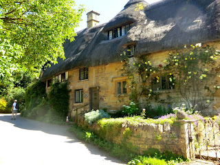
Perhaps I should begin by explaining a bit about the area. The Cotswolds are comprised of about 800 square miles that have been being shaped by man for at least the last 6000 years. It enjoys the status of “Area of Outstanding Natural Beauty” which akin to being a National Park.  As of late, lets say beginning about 1000 years ago in medieval times, the area was important for wool production - in fact the wool was known as being the the best in the world. In the old English language “cots” mean sheep enclosures and “wolds’ means hills, so we were to ramble through “sheep enclosures in the hills”.  They built these sheep enclosures,manors, shops, mills, homes, churches and stone walls from oolitic limestone that was quarried from around the area. It is this limestone that gives these ancient structures  their beautiful and famous honey colored hue.


Chipping Campden is perhaps the loveliest of the Cotswold towns. In it’s heyday it was an important wool market and has many elegant pubs, inns and shops lining both sides of the narrow road. It is here that William Grevel, who was the model for Chaucer's merchant in the “Canterbury Tales” built his home, which is still standing proudly on the high street. There is also a quaint pub called “The Eight Bells” that was originally built in the 14th century by stonemasons to house the bells of the town’s perfectly preserved church - we had dinner and an ale there- what a PERFECT way to begin our journey!

The morning brought the first sunshine England had seen in three months! As the clouds parted we began walking out of the town. Soon the road narrowed into a path and the path narrowed into our first “kissing gate” which gives easy access into the farmers fields but acts as a barrier for the animals. Then through the fields, along the hedges, over stiles, and past tiny hamlets to the ever-so-quaint town of Blockley where we stopped at the Crown pub for some refreshment. 

....Turn right and follow the road as it bends left, passes over a stream and then bends right. At this point turn left by the fingerpost along a track known as“ The Duck Paddle”. Follow the track down to a stile and gates. Go over the stile and follow the path along the edge of the field to another gate and stile. Cross the stile and then bear right up the field, following the waymarks......

The afternoon found us in some of the most delicious scenery we had ever had the pleasure to enjoy. The undulating hills, the golden wheat fields dotted with bright red poppies and the unbelievable green brilliance that IS England left us drunk with gratitude. We could see the town Moreton-in-Marsh, from high on a hill long before we got there.

Moreton-in-Marsh stands at the crossroads of a Roman Road (Fosse Way) and the old London to Worcester coach road. In bygone years the town was an important staging post and it still has a large number of 17th and 18th century coaching inns.  At about 4:00 we reached our next inn- Fosseway Farm on the outskirts of Moreton-in-Marsh and almost directly on the footpath. As promised our luggage had arrived before us and was waiting in a lovely, light filled room at the top of the stairs! Our legs were tired (the pedometer said we had walked 10 miles!) but we got cleaned up and went out to explore the town. We had a drink at the Black Bear Pub which was bustling with locals and dined at The White Hart . Sleep came easy that night- in fact I can honestly say that I slept like a log every night of this adventure!


 Morning at Fosseway Farm brought a full english breakfast comprised of fried eggs, sausage, bacon, fried tomatoes, baked beans, toast, jam, coffee and tea (this is what we fueled up on each and every morning of this trip!) After breakfast we got early start leaving the Inn at 8:00. Next stop Stow-on-the-Wold!


....at the end of the wood continue towards the small gate in the fence, from here bear left across the field to the fence opposite. Turn right and follow the path beside the fence on the left hand side to a footbridge over a small stream.....


By midday we had reached a tiny village called Longbough where the tiny shop/ post office sold culinary masterpieces and handicrafts made by the local population. What a wonderful treat to walk through a fairy tale village, untouched by time, covered in climbing roses, whose only shop showcases the local populaces talents. It brought on a big smile. The feeling that you get while you walk slowly along, each field more beautiful than the last, each tiny hamlet more enchanting, is truly why one makes this trip. We continue on.....


We arrive at Stow-on-the-Wold which literally means “town on the hill” . Unlike most of the Cotswold towns which were built by streams and rivers in the valleys, this town was built on the top of a hill and commands magnificent views. In the daytime this town bustles with activity. There are lots of walkers converging from various paths (though it was rare that we ever saw another walker while on the path!) and there are tourists by the bus load. William Morris dancers are in the streets showing examples of how the Cotswold people danced 200 years ago. There are antique shops, pubs, art galleries and a fantastic tea house called “Lucy’s” where we stopped, sat in their charming courtyard and had high tea. Then on to our (my most favorite) B&B, the South Hill Farmhouse. As luck would have it the Australian Olympic Equestrian team were also staying there and their horses were being housed at a stable about a mile away! It just gets better and better......

We did 9 1/2 miles today and since we had a tub we made the most of it by buying some epsom salts and having a soak. Juliette, our hostess, made us a scrumptious breakfast and sent us on our way with sandwiches, apples, bananas and drinks in our daypacks because  there will be nowhere to stop for a refreshment until we get to our destination in Ford. Juliet suggests we change our route and go by the stables that are housing the olympic horses, which we do-and it blows our minds when the trail takes us right through the middle of the field with the horses in it!

.........go through the pedestrian gates of Jackdaw Castle, a training stable for racehorses. Follow the tarmac driveway to a way post on the left hand side. At this point leave the driveway and bear right across the gallops. Turn left and follow the path into Ford, a sleepy hamlet comprising a handful of house around the Plough Inn.....

We past through the ancient settlement of Condicote, then on past the Donnington Brewery on the Dikler River. The brewery was closed (Sunday) but the swans were swimming on the dammed up clear pool outside. The building dates back to 1291 when it was built as a mill for the nearby Broadway Manor but it has been a brewery since 1865. Once we had past the brewery there nothing else but stunning vistas, sunshine and wind playing in the wheat fields. One could really lose ones self. We were only brought back to reality when we realized that the path had petered out and, much as we tried we could not seem to get our selves back on track. After a few frustrating times ( and several miles) of retracing our steps we decide to head straight across a field that had been planted with rapeseed. Rapeseed is a large plant that grows chest high and has thick, meaty stalks. We could see a point on the horizon that we knew we should make our way toward, a conifer farm. Off we went, muttering, and a little flustered and making a deal with ourselves that we would go back the way we came if this route didn’t pan out. But it did pan out and once we were past the field we rejoined the footpath. We continued on our way for several miles to a huge, modern, race horse training facility known as Jackdaw Castle.The footpath led us right over the training track! (the instructions warned: Be careful! Look both ways down the track! Don’t get run over by a racehorse!)

We arrive at Ford- where the only thing in town is an amazing traditional 16th century Inn called The Plough.  What a place! The pub's large outside areas are brimming with people enjoying a bright sunny day out of doors and there is an antique car club parked up and down the road adding to the scene. We are shown to one of only 3 (very comfortable) rooms where we clean up and then head for the bar. There is nothing else to do but sit back and enjoy the ambiance of a truly great British Pub. We sat in the “snug” (a snug is  a cozy small room beside the main bar- now you know ) then later dined in the larger dining room. It was wonderful and again, we slept like babies! (The pedometer read 12.7 miles).

......cross Salters Lane to the fingerpost, “public footpath, Gloucestershire Way” next to a gate. Go through the gate and follow the footpath across the field to a kissing gate opposite. In the next field continue in the same direction to another gate. Go through the gate. At this point the path divides. Turn left and follow the path uphill........

Today our walk will take us to Winchcombe, a very attractive Cotswold town that was first inhabited thousands of years ago.There are many legends and tales that make the town very interesting. There is a neolithic burial site that suggests that people have lived there since at least 2500 BC .There is an alter cloth at the town church that was made by Katherine of Aragon and remnants of a destroyed abbey that was dismantled by the Parliamentarians during the civil war. Charles 1 sought refuge in Winchcombe several times. There are also amazing caricatures of the original stonemasons all around the outside of the church which you have to see to believe.

Today's walk was an absolutely beautiful journey- for most of the day we could look out and see for miles and miles across the checker boarded english countryside. The farmers were taking full advantage of the fine weather by mowing the fields. The cattle and sheep were happily grazing in the fields. White puffy clouds passed slowly overhead. Sunshine gently kissed our faces. This is what we had come here for!

.....go though the field containing Beckbury Camp, an iron age hill fort. Turn left and follow the path.......


This evening finds us at The White Hart on the Winchcombe High Street, where we dine , have our laundry done and rest up for tomorrows adventure which will take us to Stanton.

Can it get any prettier? I have to wonder because each day seems better than the one before it. Each scene is more beautiful than the last. Each moment seems to stop just a little for you to catch up and appreciate it. Walking. This is what it is about. This is why you do these things. There is no substitute. If you want to go fast- then go on....run, drive, fly....it’s not the same thing as walking. When driving through the countryside you are a mere spectator. Walking slows you down and inserts you into the landscape. 


Can it get any prettier? Yes, the answer is yes. And it does. 

The delightful walk between Winchcombe and Stanton leads us along the Cotswold Escarpment which command sweeping views. Oliver Cromwell (who is in my family tree) once sat upon one of the hills and watched as an abbey was dismantled down below. Huge chestnut trees dot the landscape. Sheep. Cows. The slate roofs that have been ever-present in the villages we had passed thru turn to thatch. If it is possible, the Cotswolds get more quaint. The charming town of Stanton only has one pub and no stores. Our hostess had thought ahead and made us reservations at the pub for dinner. Called the Mount Inn, it served ,as with all of the places we had dined, only the freshest local fare and proved to be a very popular place. 

The following day we walked back to the town we started in, Chipping Campden. On the way we passed through a town called Broadway. Idyllic and charming, this town provided some great window shopping and a place to get rejuvenated before we walked up the very long, steep hill to Broadway Tower. An 18th century folly (meaning it served no real purpose) Broadway Tower looks as if it came straight out of Grimm's fairy tales (where was Rapunzel?). Situated at 1024 feet above sea level, from there you can see 62 miles across England and into Wales beyond. From the tower to Chipping Campden the last leg of the walk turned into a panorama of riotous colors, sweeping views and spectacular scenery. It’s like they had saved the best for last! Tired but extremely satisfied and appreciative we walked back into Chipping Campden. Which under ordinary circumstances may have been the end of the trip, but no, our good friends from London -Alison, Andy, Gerald and Lynne -all met us there! After drinks, and a wonderful Greek meal  at Michael's  ( yes Greek- but thats another story)  we all adjourned to our B&B’s and slept like logs!


Want to go on a walk?

Contours Walking Holidays
Barton House, 21 North End
Wirksworth, Derbyshire, DE4 4FG
Tel: 01629 821900 (country code 44)

Email- info@contours.co.uk
www.contours.co.uk


Sunday, March 11, 2012

Part 3 Thailand- The Beach

Smartours offers this Amazing Thailand trip three ways: you can see all of what I have written about in my previous blogs over a two week period or you can extend your travels by going to Cambodia to see Angor Wat or to Phuket Island for a three day stay on their fabled beaches. Almost everyone on the tour went to Cambodia (and they loved it) but we opted for the beach and so it was with heavy hearts that we said good bye to our fellow travelers- we had made some super new friends that miss dearly.

Our plane left out of Chiang Mai and we flew directly to Phuket Island which is located in the very southern reaches of Thailand and surrounded by the Andeman Sea just north of Malaysia.  This is the part of the journey that prompted us to actually come on this fascinating journey to begin with. Being originally from England, I have many friends and relatives that have been to these beaches  mostly in the 1980's and early 90's) and they tell tales of exciting adventure and wondrous scenery.

Our hotel, the Novotel Resort, lies on the northern part of Patong Beach- a very popular beach with westerners. It is situated on a hillside and encompasses 8 terraced acres. When the tsunami hit in 2004 Patong Beach was inundated and almost completely wiped out. Many people died and many are still missing. Our hotel was at such an elevation that it was not hit- so it is one of the few places that still remain on Patong Beach from that awful day.

The resort itself is wonderful. It looks down on Pataong Beach, a three mile sandy crescent nestled between high hills and flanked with tall palm trees. A three tiered swimming pool, several restaurants with bars and an opulent open air lobby greeted us upon our arrival. Our incredibly comfortable room was made of teak wood had sea views. It was immaculent. The sun was setting so we threw on on swimming suits and headed for the beach. Being that late in the day, the vendors and tourists were all packed up and had left. The water was crystal clear, smooth and felt like a warm bath. That was the only time we would see the beach like this, if I had known that then, I would have savored the moment a little longer, instead we strolled down the beach to a tiny open air bar frequented by Australians, had a beer and returned to the hotel for a good nights sleep.

The next morning we headed back to the beach. It had changed....now there were rows and rows of deck chairs, six or seven deep for as far as the eye could see. Each chair was filled with every kind of overweight, pudgy, pale human form you can imagine. Hundreads of heads bobbed up and down in the surf. Jet skis roared. Apparently this place is VERY popular with all manner of western tourists. In fact, there are flags on the beach that tell you where each nationalities favorite meeting spots are...there is "Swedish Beach"," German Beach", "French Beach" but far and away most people came from Australia. The strange thing was that they did not send their most attractive people to that particular stretch of Thai beach. We didn't stay long.

The next day we decided to get away from Pantong and take a tour of the outlaying Phi Phi Islands  pronounced Pee Pee). Good idea! Because once you get away from Phuket the scenery turns into a dreamscape. Between Phuket and mainland lie these wondrous small and mostly uninhabited islands. Have you ever seen the movie "The Beach"? Thats Ko Phi Phi Leh where sheer green cliffs plunge abruptly into the crystal clear, calm sea. Once again, there are WAYYY too many people trying to enjoy it and boats clutter the beaches, but you still get a sense of the beauty and we got in a couple of good swims and snorkel trips in. Our boat took us by the "viking" cave where there is a thriving industry for birds nest soup. It is too sad to talk about.

We had lunch on Ko Phi Phi Don, which is one of the only islands with a permanent human population. There you can find beach huts that can be rented out for a week at a time if you really want to get away from it all.
The beach is great, nice and sandy and dotted with colorful Thai longboats. I can certainly see why people come here!

Once again, these islands and their reefs were devastated by the tsumani but you can hardly tell (above the waterline anyway- the reefs will take a few millennium to recover). After the 2004 tsunami massive amount of workers converged on the area and rebuilt it within a year. With the exception of the ubiquitous "Tsunami Evacuation Route" signs- you really would not know that that tragic event had ever happened! The Thais' resilient spirit is amazing.

The evening brought us another dose of Patong- this time the downtown area where you find cheap shopping, gaudy trinkets, hookers, transvestites, human trafficking, garbage lined streets and debauch westerners looking for a good time....frankly, we could live with out it. It's not our cup of tea. We have seen better. We made our way back to the hotel and stopped for a beer at the open air bar again - the same Australians were there. That was our last look at Patong.

All in all, Thailand was a true adventure and I loved every minute of it-especially the things that made me scratch my head- and there were a lot of those, because that is what a life well lived is all about. Remember
this my friends - travel is the spice of life and no journey leaves you the same as you were when you embarked upon it. So get out there!

Life is like a book- and those who don't travel read only one page.- St. Augustine

Saturday, March 3, 2012

Amazing Thailand (pt 2) :Rice Paddies and Jungles

Over the next few days we traversed the "spine' of Thailand in our luxurious motor coach- going from Bangkok, which is located in the south, all the way north to where the borders of Thailand, Laos and Myanmar (Burma) meet.

We boarded our motor coach early in the morning and began plying our way through the choked Bangkok traffic heading north and following the course of the Chao Phraya River. Eventually the urban sprawl ended and we found our selves at the ruins of Ayutthaya,"The Invincible City" that was once the Capital of Siam which flourished from 1350 to 1767. At one time this city was the envy of the Eastern world and was likened by many to Paris. The city was friendly to traders and merchants. Outside of its fortified walls grew villages of Chinese, Vietnamese, Indian, Japanese, Persian, Portuguese, Dutch and French peoples. The city flourished and went through a golden age of learning, art and literature. But in 1765 an army of 40,000 Burmese attacked and after 14 months of siege the city lay in complete ruins. In fact, it was so ruined that the King decided not to rebuild it and the capital was moved south to what is now Bangkok.There is a haunting beauty about the place. Huge Buddhas still stand sentinel over the peaceful, ruined complex and the landscape is dotted with ancient pagodas. Pottery shards from the 1400's still litter the grounds around its old kilns and you can feel the ghosts of the people who once inhabited the place.


From there we boarded the bus and continued north to the city of Loburi and the Phra Prang Sam Yot, also known as the "Monkey Temple". I LOVED this place. The city was founded in the 10th century and its' beautiful and ancient Hindu Shrine in the city center is inhabited by loads of Macaque monkeys. They are revered and fed by the local people so they were quite unafraid and extremely mischievous. There are bars on the windows of the shrine, not to keep the monkeys in but in an attempt to keep them out. Three of the naughty guys jumped on my back, stole my sunglasses and climbed to the top of the temple to dismantle them. Maybe some people would not consider that the perfect day- but I did- thats the kind of stuff I came for-what an experience!

Upon leaving the town, the countryside opens up to the rich alluvial plains of the Chao Phraya River and Thailand's rice paddies reach out to the horizon. The further north you go, the prettier is gets. Occasional trees dot the flat padded fields and farmers, who still do it all by hand, can be seen working the land with their water buffalo. Further north still, mountains rise up in the smokey distance.

Eventually we come to what is known as the "Golden Triangle". This is the border of Thailand, Laos and Burma. This area is famous for its opium production , drug trade and general lawlessness. It's not pretty. It's weird. The muddy Mekong River divides the three countries, and when standing high on its banks on the Thai side you can see the differences in all three.

I suppose, since the big pharmaceutical companies dispense drugs like candy these days, there really is no need for the old opium growers anymore so they have turned to, guess what? Casinos! Who would have ever guessed that the drug cartel/ mafia would now build casinos and make their billions legally? (Yes, I am being sarcastic). Standing on the bluffs right next to an enormous golden statue of Buddha you can look across the river and see Laos. The  river banks have been stripped of all vegetation and rip-rap grey rocks have been poured down to the river from top to bottom. A huge, band new casino stands menacingly in the center of a sea of concrete. Lovely! Looking west to what is now called Mynamar  (old Burma) you see another enormous casino complex under construction. This one is surrounded by green delta land and in contrast to the one in Laos looks almost inviting. We took a boat ride over to Laos where we hung out on an old, dumpy market area filled with starving dogs and cheap trinkets. Don't do that. Just skip it.

More interesting, but certainly not more beautiful , are the hill tribe people that are still found in the region. These are people who have fled from Burma because of genocide about 300 years ago. They found Thailand's mountains and jungles an easy place to lead their nomadic lifestyle. To make a living they grew poppies and cultivated opium. Since the mountain's soil is thin they practice slash and burn techniques leaving a landscape of waste and destruction in their wake. Only 18 percent of Thailand's forested jungles remain. The rest have been destroyed by these tribes (and no doubt illegal loggers and other commercial interests). The government finally took some notice a few years back and have been trying to infuse the area with some financial aid to help get the tribes get off the opium trade and change their practices- but at the moment the prospects for the jungle still look pretty grim. The "jungle" in this area, which was once home to elephants, tigers and the clouded leopard, now looks like a strip mining operation from West Virginia.

My favorite activities in this area of Thailand was visiting the elephants at the Measa Elephant camp outside of Chaing Mai. Here we spent some time feeding the elephants bananas and sugar cane, watching them paint pictures ( yes, we did!) and taking an hour trek though the forest on a 41 year old elephant named Kamine. I had finally found the lush landscape that I had been imagining! The following day we went on a zip line adventure through the canopy of the forest and saw Gibbons monkeys! Don't miss these things- they are magical and you will remember them for a lifetime.....you might even become interested in the plight of the south east asian wildlife and choose to help via the Wildlife Conservation Society who is trying to protect their habitat- no doubt they need you! Go to www.wcs.org

These are the highlights of our trip to through the Thai countryside, it took us 7 days to explore and I am sure you will need at least that much time if you decide to go and take a look.  From here we flew from the Chaing Mai airport to the island of Phuket for 3 days on the famous beach.....that will be the final installment of my amazing adventure through Thailand.